|
| Author | Message |
|---|
Triceratops
Censura

Posts : 4377
Join date : 2012-01-05
 |  Subject: Alternative Cartography Fri 27 Apr 2012, 15:08 Subject: Alternative Cartography Fri 27 Apr 2012, 15:08 | |
| Throughout the last couple of hundred years, cartoonists have produced satirical and humorous maps. Please post your favourites. Start with this one from 2009 of a view of the Great War  |
|
| | |
Triceratops
Censura
Posts : 4377
Join date : 2012-01-05
| | Subject: Re: Alternative Cartography Fri 27 Apr 2012, 15:12 | |
| and from 1914  |
|
| | |
Triceratops
Censura
Posts : 4377
Join date : 2012-01-05
| | Subject: Re: Alternative Cartography Fri 27 Apr 2012, 15:16 | |
| Shamelessly stolen from historum, the Texan map of the USA  |
|
| | |
Triceratops
Censura
Posts : 4377
Join date : 2012-01-05
| | Subject: Re: Alternative Cartography Fri 27 Apr 2012, 15:34 | |
| An American view of Europe;  |
|
| | |
Islanddawn
Censura

Posts : 2163
Join date : 2012-01-05
Location : Greece
| | Subject: Re: Alternative Cartography Fri 27 Apr 2012, 15:42 | |
| I was going to upload that one too Trike, as a modern version of satirical maps. The are lots of different versions of that one too, according to who is doing the viewing. But here is one from circa 1870.  |
|
| | |
Triceratops
Censura
Posts : 4377
Join date : 2012-01-05
| | Subject: Re: Alternative Cartography Fri 27 Apr 2012, 16:11 | |
| That's a good one ID.
I couldn't find one of the Channel Islands to welcome A-N.
Trike |
|
| | |
Islanddawn
Censura
Posts : 2163
Join date : 2012-01-05
Location : Greece
| | Subject: Re: Alternative Cartography Fri 27 Apr 2012, 16:32 | |
| |
|
| | |
ferval
Censura

Posts : 2602
Join date : 2011-12-27
| | Subject: Re: Alternative Cartography Fri 27 Apr 2012, 17:08 | |
| I love this, it's very recent, by Grayson Perry, but in the style of the Mappa Mundi  There was a great series on BBC, Maps:Power,Plunder and Possession. It's no longer on iplayer but there's some info and clips here http://www.bbc.co.uk/programmes/b00s2wvh |
|
| | |
Triceratops
Censura
Posts : 4377
Join date : 2012-01-05
| | Subject: Re: Alternative Cartography Sat 28 Apr 2012, 08:15 | |
| |
|
| | |
Triceratops
Censura
Posts : 4377
Join date : 2012-01-05
| | Subject: Re: Alternative Cartography Fri 04 May 2012, 16:05 | |
| |
|
| | |
Triceratops
Censura
Posts : 4377
Join date : 2012-01-05
| | Subject: Re: Alternative Cartography Sat 05 May 2012, 17:58 | |
|  Gillray's cartoon of Napoleon and Pitt carving up the globe. |
|
| | |
Triceratops
Censura
Posts : 4377
Join date : 2012-01-05
| | Subject: Re: Alternative Cartography Tue 15 May 2012, 09:00 | |
| One of a number of "Leo Belgicus" maps, showing the Netherlands as a lion  |
|
| | |
Triceratops
Censura
Posts : 4377
Join date : 2012-01-05
| | Subject: Re: Alternative Cartography Wed 16 May 2012, 10:19 | |
| Asia depicted as Pegasus;  |
|
| | |
Triceratops
Censura
Posts : 4377
Join date : 2012-01-05
| | Subject: Re: Alternative Cartography Wed 16 May 2012, 14:17 | |
| The world of Orwell's 1984;  |
|
| | |
Triceratops
Censura
Posts : 4377
Join date : 2012-01-05
| | Subject: Re: Alternative Cartography Wed 16 May 2012, 15:16 | |
| |
|
| | |
Triceratops
Censura
Posts : 4377
Join date : 2012-01-05
| | Subject: Re: Alternative Cartography Thu 17 May 2012, 12:01 | |
| A map of the United States with each state represented by the flag of the nation which is nearest to it in population. Thus Ohio/Greece, Kansas/Jamaica and Texas/North Korea.  |
|
| | |
Triceratops
Censura
Posts : 4377
Join date : 2012-01-05
| | Subject: Re: Alternative Cartography Thu 17 May 2012, 12:03 | |
| The Kaiser eats up the world.  |
|
| | |
Triceratops
Censura
Posts : 4377
Join date : 2012-01-05
| | Subject: Re: Alternative Cartography Fri 30 Aug 2013, 12:25 | |
| |
|
| | |
Triceratops
Censura
Posts : 4377
Join date : 2012-01-05
| | Subject: Re: Alternative Cartography Thu 06 Mar 2014, 16:14 | |
| Map showing proposed US States;  though there are at least two missing, the State of Transylvania, between Kentucky and Ohio and the State of Sequoyah in eastern Oklahoma |
|
| | |
Triceratops
Censura
Posts : 4377
Join date : 2012-01-05
| | Subject: Re: Alternative Cartography Fri 13 Jun 2014, 09:12 | |
| |
|
| | |
nordmann
Nobiles Barbariæ

Posts : 7223
Join date : 2011-12-25
| | Subject: Re: Alternative Cartography Mon 16 Jun 2014, 08:55 | |
|  The "Tabula Rogeriana". Arab geographer Abu Abd Allah Muhammad al-Idrisi al-Qurtubi al-Hasani al-Sabti (who thankfully is referred to more often simply as "El Idrisi"), produced a map of the known world in 1134 which survives to this day in the form of the above copy from 1300. Working for Roger, Count of Sicily, his atlas was to remain the authoritative Euro-centric depiction of the lands then within reasonable navigable distance from the Mediterranean for over 300 years. If it looks strange to you then bear in mind that "north" and "south" are artificial constructs. We have simply got used in the meantime to seeing the world the other way up. |
|
| | |
Triceratops
Censura
Posts : 4377
Join date : 2012-01-05
| | Subject: Re: Alternative Cartography Fri 14 Nov 2014, 12:38 | |
| Louis Bezenet's 1918 map of Europe drawn along ethnic lines;  |
|
| | |
Triceratops
Censura
Posts : 4377
Join date : 2012-01-05
| | Subject: Re: Alternative Cartography Fri 14 Nov 2014, 13:20 | |
| Map from 2006, by Ralph Peters, showing the Middle East divided along religious and ethnic boundaries;  |
|
| | |
Vizzer
Censura

Posts : 1808
Join date : 2012-05-12
| | Subject: Re: Alternative Cartography Sat 15 Nov 2014, 17:34 | |
| Interesting map that by Ralph Peters. The problem with his various pronouncements on Iraq and Yugoslavia etc is that he invariably appears to be wise after the event. And this characteristic is all too evident in far too many of the NATO establishment. Here's a variation of the many 'upside down' maps popular with Antipodeans: 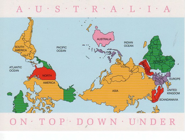 The reason why Claudius Ptolemy chose to position his maps facing north is not clear. One theory is that living in Alexandria and being of Greek heritage would have given him 3 factors prompting this Boreal 'orientation'. The fact that the river Nile flows south to north and that Alexandria is on the north coast of Egypt, with Greece itself being further north again across the sea could explain this decision. |
|
| | |
Sponsored content
| | Subject: Re: Alternative Cartography | |
| |
|
| | |
|


