Subject: Re: Walls and Frontiers in History Thu 28 May 2015, 10:24
The "Siegfried Line" fortifications in the Hurtgen Forest on the Belgian-German border were the scene of a bloody, and nowadays largely forgotten, battle in the Autumn of 1944;
photo of German bunker in the Hurtgen;
Triceratops Censura
Posts : 4377 Join date : 2012-01-05
Subject: Re: Walls and Frontiers in History Thu 28 May 2015, 10:46
Subject: Re: Walls and Frontiers in History Thu 28 May 2015, 19:42
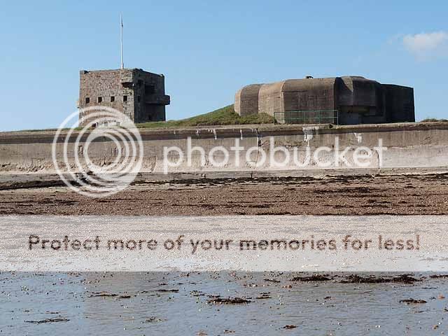
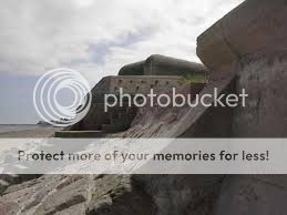
Here are some photos of fortifications in Jersey. First: Fort Henry (originally Fort Conway) was built in the 1760s. However, the 'ear' you can see projecting from the tower (there's a matching one on the other side) was a searchlight platform. You can see the big hole cut out of the tower to house the searchlight when not in use. The Fort also had a bunker underneath and a 'six-shooter' machine-gun turret housing three MG34 machine-guns. In front, a nice view of the anti-tank wall and one of a pair of coastal defence bunkers, each originally housing a 10.5cm gun. Additionally this 'Resistance Nest' also featured two further MG34s, two mortars, no fewer than ten flame-thrower emplacements and a minefield. Welcome to Jersey!
Machine-gun emplacement at Resistance Nest Fort Henry. The second of the two 10.5cm bunkers can be seen behind.
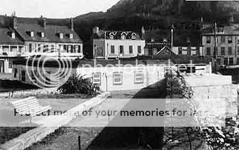
Bunker on Gorey Pier, with trompe-l'oeil camouflage made to look like a cottage with white walls and red-tiled roof. This is one of the few which were demolished, but the bunkers are Fort Henry were similarly painted (one even had a trellis with roses!) - a bit more imaginative than the usual green-and-brown splodges!
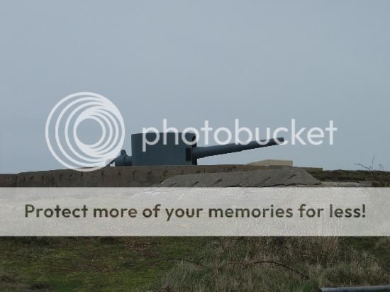
Some of the sites have been restored. This is Battery Lothringen at Noirmont, with its massive range-finders (the turret is a partial replica, but the two periscope cupolas, with 7in thick armour, are original and the only ones of their type to survive). Beneath, the command bunkers extends to 40ft on two levels, dug through solid granite.
One of Lothringen's 15cm guns (originally four, though only three survive). The barrel is original (thrown over the cliff after the War) but the mounting and shield are replicas. The gun platforms are outsized because it was originally intended to replace the guns with larger calibre weapons; however, this never happened.
Triceratops Censura
Posts : 4377 Join date : 2012-01-05
Subject: Re: Walls and Frontiers in History Fri 29 May 2015, 11:56
Terrific pictures there, A-N.
Here's one of the Austratt Fort in Norway, now a museum. The triple gun turret is from the Gneisenau.
The fort was kept in a working condition into the 1970s, and is well preserved;
ferval Censura
Posts : 2602 Join date : 2011-12-27
Subject: Re: Walls and Frontiers in History Fri 29 May 2015, 14:26
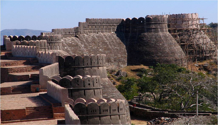
We hear a lot about the Antonine Wall as the 'most northerly frontier' of the Roman Empire but rarely about what was the real most northerly - and possibly the earliest - fortified frontier, the Gask Ridge Frontier. Running from near Stirling to the banks of the Tay, it effectively monitors the route between the central belt and the highlands and is traditionally ascribed to Agricola after 79CE although there is some evidence it was occupied before that. Although there is no wall there is an all weather road and strung along it are 3 large forts, at least 18 smaller forts with watch towers and at least 3, probably many more, fortlets. Further north were the about 10 'glenblocker' forts and the legionary fortress at Inchtuthill.
The first occupation lasted around 8 years but the large forts at least were refurbished and reused under Antoninus and some again utilised by Severus. In adition the area is littered with temporary camps from each period, the largest covering 144 acres. Sept sev is said to have invaded with a force of 30,000, something which I find impossible to imagine while passing through this douce and peaceful countryside today.
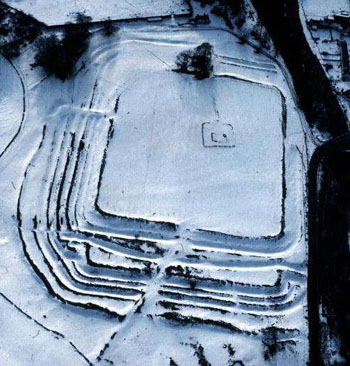
The Ardoch fort is really 3 forts on the same site: the first is Flavian, the later 2 Antonine and elements of all 3 are still visible. Here it is under snow:
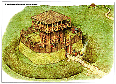
Reconstructed watch tower (single ditch, some had a double ditch:
Anglo-Norman Consulatus
Posts : 278 Join date : 2012-04-24
Subject: Re: Walls and Frontiers in History Fri 29 May 2015, 21:45
Triceratops wrote:
Here's one of the Austratt Fort in Norway, now a museum. The triple gun turret is from the Gneisenau.
Intriguing! I hadn't realised any parts of the Gneisenau survived. The Scharnhorst-class were beautiful ships, and formidable opponents, too.
PaulRyckier Censura
Posts : 4902 Join date : 2012-01-01 Location : Belgium
Subject: Re: Walls and Frontiers in History Sun 31 May 2015, 21:55
Triceratops wrote:
The "Siegfried Line" fortifications in the Hurtgen Forest on the Belgian-German border were the scene of a bloody, and nowadays largely forgotten, battle in the Autumn of 1944;
I read about it in a book of an American soldier, who was there during the campaign. The Americans couldn't understand that the Germans, who were already nearly beaten, could nevertheless do still such an effort to resist. In the book the said man had a very moment a nervous breakdown in the forest and when he saw a head from a German decapitated by an explosion he started to play football with the head...see what I do to you bloody bastard...instead of recognizing the fait accompli still fighting ever and ever again...after a while he became again normal in the face of his compagnions...
And yes, the Ardennes offensive (the battle of the Bulge) had still to begin...
Kind regards and with esteem, Paul.
Vizzer Censura
Posts : 1818 Join date : 2012-05-12
Subject: Re: Walls and Frontiers in History Sat 06 Aug 2022, 23:27
nordmann wrote:
And perhaps Britain's most recent defensive dyke, the Scots' Dyke separating "The Debatable Lands" from civilisation
I could never work out why there was a debate at all. In terms of natural boundaries, the obvious choice of border between Scotland and England would be the river Esk. Its mouth is the furthest limit east of the Solway Firth and its course is the most direct to the Cheviot watershed. This would give an easy-to-understand border going up the Esk in the west, along the Cheviot watershed and then down the Tweed in the east. Why anyone got the idea that both the river Esk and the river Sark should form the border in the west is puzzling. Even the alphabet points the way. The 3 main rivers which flow into the Solway Firth are:
Sark Esk Eden
The farthest north of the 3 (the Sark) begins with the letter S thus indicting that that river is in Scotland, the farthest south of the 3 (the Eden) begins with the letter E thus indicating that that river is in England while the one in the middle (the Esk) begins with the letters E and S thus indicating that it is half in England and half in Scotland so marking the border. Yet even Robert Burns in his 1791 poem A Parcel o’ Rogues named the river Sark as the border thus selling Scotland short himself.
It’s not just at its western end, however, that the Scotland-England border is debatable. At its eastern end the town of Berwick upon Tweed (ostensibly in England) is located on the Scottish, northern bank of the river. The town’s football team Berwick Rangers even plays in the Scottish League. That said (and just to confuse matters) the club’s ground is located in Tweedmouth on the English, southern bank of the river.
There are other anomalies too. When the Commonwealth of Nations Games were held in Glasgow in 2014 the Queen’s Baton in the run-up to the games highlighted one of these. The Queen’s Baton relay is divided into 2 sections – the international leg (around the Commonwealth member states) and the host leg (around the host country). In 2014 when the Baton relay entered Scotland (i.e. moving from the international leg to the host leg) it came via England and crossed over the River Tweed at Coldstream Bridge. That makes sense, one might think with the River Tweed marking the natural boundary between Scotland and England. And the River Tweed does indeed mark the border for much of its length, but in order the reach the Cheviot watershed by the quickest route and following natural boundaries, the border would leave the Tweed and go up its tributary the Till and up the Till's tributary the Glen and then up the Glen’s source burns to The Cheviot. As it stands, however, the official border quits the Tweed about 2 miles west of Coldstream and then arbitrarily heads off cross country in an erratic attempt to reach the Cheviot watershed. The natural boundary (i.e. the course of the Till) leaves the Tweed 2 miles to the east of Coldstream. In other words, both banks of the Tweed at Coldstream would be in Scotland. This would include Flodden Field the site of a battle in 1513 in which a Scottish army led by King James IV was defeated and an English army led by Thomas Howard earl of Surrey. King James and a large number of Scottish nobles along with other soldiers lost their lives that day and the song The Flowers of the Forest is a lament on the battle which contains the line:
Dule and wae for the order sent our lads to the Border
Note the use of the term ‘to the Border’ rather than ‘across the Border’.
It’s not all one-way traffic, though, in terms of land along the border being naturally in Scotland but officially in England. Further west from Coldstream along the Cheviot watershed there are a couple of stretches of the border in the vicinity of Kershope Castle and the Kielder Observatory where for some reason the official border drops several hundred yards south of the natural watershed leaving the headwaters of some English streams there officially in Scotland.
(The Coldstream Bridge over the river Tweed was only 10 years old when the Scottish poet Robert Burns crossed it in 1787. This being his first trip to England he knelt and prayed for a blessing on his native land. The natural boundary, however, would actually be over the river Glen 7 miles further south.)
29 years after Flodden, Scotland and England were again at war when this time Henry VIII sought to intimidate his nephew king James V into following his lead and breaking with Rome. A battle was fought at Solway Moss and (as at Flodden) a large Scottish army was defeated by a much smaller English force. It was a battle fought in boggy land on both banks of the river Esk including the southern part of the Debateable Lands. Although a humiliating rout, the battle itself was not decisive and James intended to continue to resist Henry. The 30-year-old James, however, suddenly took ill and died 3 weeks after the battle. During those 3 weeks his wife Marie de Guise had been delivered of a baby girl (James’ only heir) and with James dead, Henry now redoubled his effort to extend his influence in Scotland by insisting that the newborn infant be betrothed to his 5-year-old son Edward. This proposal was rejected by the Scottish parliament and the country descended into a sectarian civil war between a protestant pro-English party and a catholic pro-French party. Henry sought to exploit this division, intervene on the side of the protestants and press his claim with a campaign in Scotland which would become known as the Rough Wooing. One such intervention involved an amphibious attack upon Edinburgh in 1544 in which the attackers avoided engaging the city’s garrison in the castle but instead proceeded to burn down the homes of civilians in Edinburgh and in other neighbouring towns and villages.
Such conduct by the English troops, by which they lived out the worst caricature of themselves as history’s cartoon baddies, predictably saw many of the pro-English element in Scotland turn against them and support the wider patriotic cause. Such was the scale and commitment of Henry’s policy, however, that the war did not end with his death in 1547. Anyone thinking that a change of king would see an end to the war was sorely mistaken. The war was continued under the regent Edward Seymour (the maternal uncle of Henry’s nine-year-old son King Edward) and, if anything, even more vigorously than it had been under Henry. Seymour identified closely with the war as he had been personally in charge of the English forces at Edinburgh.
(Margaret Tudor, the elder sister of England’s Henry VIII. She was married to James IV of Scotland who died in battle against his brother-in-law’s army at Flodden. Margaret’s own death in 1541 followed by that of her son James V a year later plunged Scotland into a constitutional crisis which transformed a border dispute into an existential war with England.)
Both Scotland and England were now ruled by regents. One sought to enforce marriage between their respective wards while the other resisted same. Seymour launched an enormous invasion that year which prompted the Scottish regent James Hamilton (himself previously protestant and pro-English) to seek direct naval and military assistance from France. A stalemate ensued whereby virtually the whole of southern Scotland (except Edinburgh Castle and Dunbar Castle) was under English occupation while the rest of Scotland resisted with the support of increasing numbers of French troops. To break the deadlock Hamilton brought an end to the war by removing Seymour’s casus belli. The now 5-year-old Mary, Queen of Scots was betrothed to France’s 4-year-old Dauphin Francois and spirited away to France. Outmanoeuvred, and having spent so much blood and treasure on the war in Scotland, things only got worse for Seymour. In the summer of the following year 1549 he faced 2 serious domestic revolts, the Prayer Book Rebellion in Cornwall and Devon and also Kett’s Rebellion in Norfolk. These he saw off but not before having lost credibility in the eyes of the other members of the Regency Council and he was removed from office.
Peace with France was then concluded by the Treaty of Boulogne in 1550 and with Scotland by the Treaty of Norham in 1551 and English forces began withdrawing from Scotland. The terms of the latter treaty would see a commission of Scottish and English representatives meet to agree the settlement of the border with the French ambassador to act as mediator. One of the English commissioners was Sir Thomas Wharton who had commanded the English forces at Solway Moss and it’s believed that he was loath to abandon the site of his famous victory so played hard-ball in the negotiations. A highly skilled diplomat, the French ambassador Henri Cleutin d'Oysel, suggested a compromise whereby the Lands Debateable would be partitioned by a line running almost perpendicular between the rivers Sark and Esk. This would mean that the bulk of the Lands would be apportioned to Scotland while a triangular-shaped section at the southern end (including Solway Moss) would be apportioned to England. A dyke would then be cut to confirm the delineation. Exhausted after years of strife and bloodshed, both sides agreed to the compromise and so literally drew a line under the past.
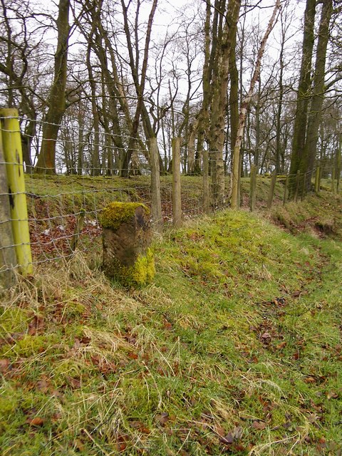
(A boundary stone, a dyke, a plantation of trees and even a barbed wire fence leaving one in no doubt as to the existence of a border at Scots’ Dike.)
MarkUK Praetor
Posts : 142 Join date : 2022-03-13 Location : Staffordshire
Subject: Re: Walls and Frontiers in History Sun 07 Aug 2022, 08:36
Borders have always fascinated me. I particularly like looking at OS maps in which a County border runs along a river. In places it deviates from the course of the river into a wobbly line before rejoining the river. Presumably the border, which was deliniated centuries ago, followed the river as it was then, over successive years the course of the river changed leaving the border "stranded" for a short distance over fields, that's how I see it anyway. And of course there are (or rather were) County enclaves/exclaves - areas of land administered by one County but isolated in another. Many were absorbed into the surrounding County in the 19th century, but others survived into the 20th. Dudley is a good example - part of Worcestershire despite being entirely within Staffordshire until 1966 when it was absorbed into Staffordshire. Since then of course it has become part of West Midlands County.
Meles meles Censura
Posts : 5083 Join date : 2011-12-30 Location : Pyrénées-Orientales, France
Subject: Re: Walls and Frontiers in History Sun 07 Aug 2022, 10:44
What is now called the Scots' Dyke was originally more often known as the March, or Marches, Dyke - that is the frontier through the Marches or border lands, where the uncertain allegences of the local families - albeit always steadfast to their own kith and kin - made it an area notorious for cattle raiding, smuggling, hostage-taking and general lawlessness. Nominally the area was under the control of semi-autonomous Wardens of the Marches (there were both English and Scots Wardens who were supposed to liase with each other and manage the area together) but in practice the local families (the Grahams, Armstrongs, Elliots and Bells) were too powerful and the official Wardens, of both sides, largely left them alone. I suspect the arrangement probably suited both national governments as it created a buffer zone where neither country was willing nor able to enforce its jurisdiction.
By the original terms of the 1552 agreement the border - later to be physically delineated by the March Dyke - was defined as a straight line running eastwards from the 'source' of the River Sark (albeit geographically that's a rather ambiguous location as the headwaters of the River Sark originate in a notoriously marshy area without any distinct surface streams), but then across to the point on the River Esk in line with and directly opposite 'the house of Fergus Graham'. This house no longer exists and its exact location is uncertain however it was probably specified because it was then a prominent landmark that could be used for triangulating/surveying the border's route. Accordingly it was likely located very close to the current March Bank Hotel (Longtown, Cumbria), the current buildings of which were constructed in the mid-19th century on a prominent hill "with commanding views of the surrrounding countryside" (to quote from the hotel's website) as a hunting lodge for the descendants of the same Graham family (at that time still big land-owners in the area). Moreover the March/Scots' Dyke cuts across the end of the hotel's garden about one hundred metres away from the current hotel buildings.
Anyway the border dyke when it finally came to be dug, was actually two ditches and a mound, the so-called Scots' dyke and the adjacent English dyke, the two roughly twelve feet apart and dug parallel to each other, with the soil from both thrown into the middle to create a continuous ridge (the border dyke proper). It is not completely straight as the two ditches on either side were started simultaneously from opposite ends and almost inevitably where they met they were not completely in alignment so there is a slight dog-leg roughly halfway along. Plain border stones were placed at intervals along the top of the central earthwork but at each end there were larger border stones with more elaborate carvings. Some reports say these had an English Rose carved on one side and a Scottish Lion on the other, while others say they had a George cross on one side and a Scottish saltire on the other. Still other descriptions say that both sides were marked with a simple cross pattée, which would actually be in accordance with what was originally agreed by the commissioners in 1552. Note also that the Ordnance Survey, having repeatedly resurveyed the route since the 19th century, say that many of the existing border stones along the route seem to have been moved from their original positions and some are not even contemporary with when the dyke was constructed.
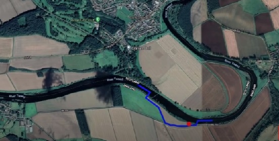
There is another quirk with the Scottish/English border towards the eastern end. The border here is generally defined as a line running along the mid point of the River Tweed, however just south of the town of Coldstream in Scotland the border deviates a bit where there is a small field of about a hectare in size on the English side of the river that is actually Scottish - in this google-earth screen shot it's the bit bounded in blue on the southern side of the river:
Very often, like MarkUK says, such oddities are likely due to the changing course of the river over time, but that is not the case here. The small plot of land is located about a mile directly south of Coldstream in Scotland and about the same distance due east of the hamlet of Wark on the English side of the river. Back in the day they were both similarly-sized villages and they used to play an annual rough-and-tumble type of medieval football/rugby match. The riverside field in question is still known as the Ba Green and while the name is apparently "of uncertain origin" it's certainly tempting to see it as related to the Scottish pronunciation of football as "fitba". This small parcel of riverside meadow was originally matched by a similarly-sized plot directly opposite on the other side of the river (a ghost of it is perhaps visible in the google earth photo). Whichever town's team won the ball game got to keep and use the other side's field containing their goal, at least until the next year's match. So one year the land might be part of Wark in England, the next possibly owned by Coldstream in Scotland, based simply on the result of the footy match. However over time Coldstream grew into a sizeable market town able to field a strong team, while Wark withered into a tiny hamlet ... and so never again did it come home to Wark. That's why the English end of the 'pitch' is now part of Scotland because it is currently by ancient right part of the town of Coldstream, simply because Wark has never yet managed to win it back.
Last edited by Meles meles on Mon 08 Aug 2022, 19:48; edited 9 times in total
Meles meles Censura
Posts : 5083 Join date : 2011-12-30 Location : Pyrénées-Orientales, France
Subject: Re: Walls and Frontiers in History Mon 08 Aug 2022, 10:11
A few miles downstream from Coldstream, between the villages of Fishwick (Scotland) and Horncliffe (England) there's another tiny plot of land on the 'wrong' side of the border, but here it's a little bit of England on the Scottish side of the River Tweed. You can see the border marked out on the Ordnance Survey map here, where my 'pin' marks the location of the abandoned medieval village of Fishwick in Scotland - the current 'village' being just a few scattered farms which are now parochially absorbed into the villages of Hutton and Paxton.
I don't know what the history of this little border quirk is - and it is tiny, smaller in area than the contested bit of pasture between Wark and Coldstream. Is it the result of another long-abandoned football rivalry perhaps, or maybe it's something to do with the medieval village of Fishwick originally being a possession of Coldingham Priory (in Scotland) which was a cell of the Bishopric of Durham (in England)?
Meles meles Censura
Posts : 5083 Join date : 2011-12-30 Location : Pyrénées-Orientales, France
Subject: Re: Walls and Frontiers in History Sun 14 Aug 2022, 09:33
MarkUK wrote:
I particularly like looking at OS maps in which a County border runs along a river. In places it deviates from the course of the river into a wobbly line before rejoining the river. Presumably the border, which was deliniated centuries ago, followed the river as it was then, over successive years the course of the river changed leaving the border "stranded" for a short distance over fields, that's how I see it anyway.
The changing courses of rivers has certainly created some quirky border situations, as in the following Tim Traveller youtube: What happens to a border if the river changes course?