|
| | Author | Message |
|---|
Triceratops
Censura

Posts : 4377
Join date : 2012-01-05
 |  Subject: Antique Maps & Explorers Thu 06 Jul 2017, 13:50 Subject: Antique Maps & Explorers Thu 06 Jul 2017, 13:50 | |
| Around 1450, an Italian cartographer named Fra Mauro created a world map, based on the best available evidence of the time. Fra Mauro Map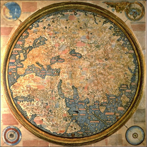 Unsurprisingly, North and South America as well as Antarctica are absent, however, the Indian Ocean is shown linked to the Atlantic. This, remember, on a map produced around the same year Bartholomew Diaz was born.
Last edited by Triceratops on Thu 06 Jul 2017, 14:00; edited 1 time in total |
| | | | Triceratops
Censura
Posts : 4377
Join date : 2012-01-05
| | Subject: Re: Antique Maps & Explorers Thu 06 Jul 2017, 13:53 | |
| Wiki; The Indian Ocean is depicted as connected to the Atlantic. Several groups of smaller islands such as the Andamans and the Maldives are shown. Fra Mauro puts the following inscription by the southern tip of Africa, which he names the "Cape of Diab", describing the exploration by a ship from the East around 1420: "Around 1420 a ship, or junk, from India crossed the Sea of India towards the Island of Men and the Island of Women, off Cape Diab, between the Green Islands and the shadows. It sailed for 40 days in a south-westerly direction without ever finding anything other than wind and water. According to these people themselves, the ship went some 2,000 miles ahead until - once favourable conditions came to an end - it turned round and sailed back to Cape Diab in 70 days". "The ships called junks (lit. "Zonchi") that navigate these seas carry four masts or more, some of which can be raised or lowered, and have 40 to 60 cabins for the merchants and only one tiller. They can navigate without a compass, because they have an astrologer, who stands on the side and, with an astrolabe in hand, gives orders to the navigator". (Text from the Fra Mauro map, 09-P25.) Fra Mauro explained that he obtained the information from "a trustworthy source", who traveled with the expedition, possibly the Venetian explorer Niccolò da Conti who happened to be in Calicut, India at the time the expedition left: ...................................................................................................................................................................... Bartholomew Diaz
Last edited by Triceratops on Thu 06 Jul 2017, 14:06; edited 2 times in total |
| | | | Triceratops
Censura
Posts : 4377
Join date : 2012-01-05
| | Subject: Re: Antique Maps & Explorers Thu 06 Jul 2017, 14:02 | |
| The Martellus Map of 1490, just prior to the exploration voyages of the Western Atlantic. The Cape of Good Hope is now a confirmed reality; 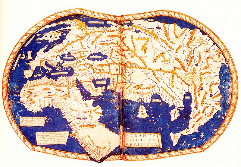 |
| | | | Triceratops
Censura
Posts : 4377
Join date : 2012-01-05
| | Subject: Re: Antique Maps & Explorers Thu 06 Jul 2017, 14:14 | |
| Reconstruction of Toscanelli's 1474 map of the Atlantic and the speculated Western route to Asia: 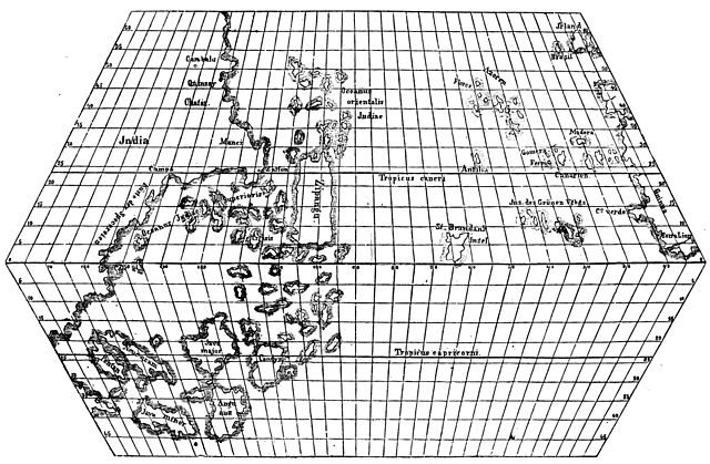 The distance between Europe and Asia was seriously underestimated. |
| | | | Triceratops
Censura
Posts : 4377
Join date : 2012-01-05
| | Subject: Re: Antique Maps & Explorers Thu 06 Jul 2017, 14:35 | |
| The Kangnido Map of 1402. Originating in Korea, this map was probably used by the Chinese Admiral, Zheng He, during his voyages to the Western ( ie Indian ) Ocean in the 1420s: Zheng He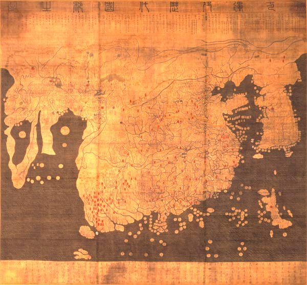 |
| | | | Triceratops
Censura
Posts : 4377
Join date : 2012-01-05
| | Subject: Re: Antique Maps & Explorers Thu 06 Jul 2017, 14:50 | |
| The largest ships in Zheng's fleet were around 400 feet in length:  |
| | | | Triceratops
Censura
Posts : 4377
Join date : 2012-01-05
| | Subject: Re: Antique Maps & Explorers Thu 06 Jul 2017, 14:53 | |
| |
| | | | Triceratops
Censura
Posts : 4377
Join date : 2012-01-05
| | Subject: Re: Antique Maps & Explorers Thu 06 Jul 2017, 15:15 | |
| Classic image of Santa Maria, Pinta and Nina during Columbus's 1492 voyage;  Route of Columbus's 4 voyages: 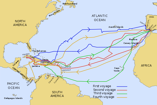 |
| | | | Triceratops
Censura
Posts : 4377
Join date : 2012-01-05
| | Subject: Re: Antique Maps & Explorers Thu 06 Jul 2017, 15:20 | |
| The Waldseemuller Map of 1507. The first map to use the word "America". Waldseemuller Map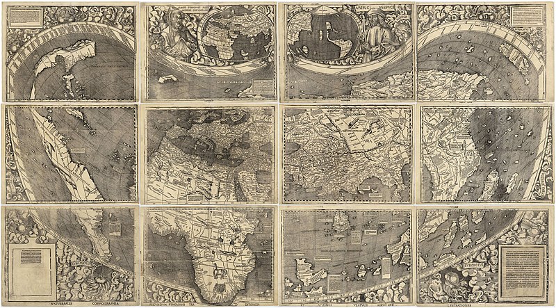 |
| | | | Meles meles
Censura
Posts : 5122
Join date : 2011-12-30
Location : Pyrénées-Orientales, France
| | Subject: Re: Antique Maps & Explorers Thu 06 Jul 2017, 16:06 | |
| - Triceratops wrote:
- Reconstruction of Toscanelli's 1474 map of the Atlantic and the speculated Western route to Asia:
The distance between Europe and Asia was seriously underestimated. Isn't that the source Columbus primarily used to try and convince potential backers of his scheme that it was possible? This was of course against all learned opinion based on numerous measurements going back to Erastosthenes (3rd century BC), that said, quite correctly, that the distance westward between Europe/Africa and the nearest eastern coast of China/Japan was far longer than a ship of the time could possibly traverse without replenishing food and water. As you say "the distance between Europe and Asia was seriously underestimated", and so Columbus's voyage wasn't feasible ... unless he luckily found a completely new continent half-way ... somewhat after the point of no return by which time his supplies were already too low to get him home. |
| | | | Triceratops
Censura
Posts : 4377
Join date : 2012-01-05
| | Subject: Re: Antique Maps & Explorers Thu 06 Jul 2017, 16:14 | |
| Precisely, Meles. If America hadn't been there, Columbus and his ships would have vanished into a an Atlantic-Pacific super ocean. Real world map, superimposed on Toscanelli's: 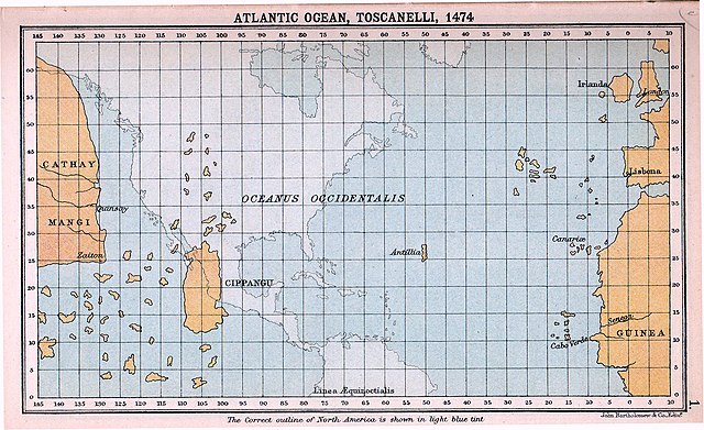 |
| | | | Triceratops
Censura
Posts : 4377
Join date : 2012-01-05
| | Subject: Re: Antique Maps & Explorers Thu 06 Jul 2017, 16:17 | |
| Western Super-Ocean:  |
| | | | Vizzer
Censura

Posts : 1853
Join date : 2012-05-12
| | Subject: Re: Antique Maps & Explorers Mon 10 Jul 2017, 21:12 | |
| - Meles meles wrote:
- Triceratops wrote:
- Reconstruction of Toscanelli's 1474 map of the Atlantic and the speculated Western route to Asia:
The distance between Europe and Asia was seriously underestimated.
Isn't that the source Columbus primarily used to try and convince potential backers of his scheme that it was possible? This was of course against all learned opinion based on numerous measurements going back to Erastosthenes (3rd century BC), that said, quite correctly, that the distance westward between Europe/Africa and the nearest eastern coast of China/Japan was far longer than a ship of the time could possibly traverse without replenishing food and water. As you say "the distance between Europe and Asia was seriously underestimated", and so Columbus's voyage wasn't feasible ... unless he luckily found a completely new continent half-way ... somewhat after the point of no return by which time his supplies were already too low to get him home. It also explains why Columbus insisted on sailing south-west rather than due west or even north-west on his voyages. On his 3rd voyage, for example, he sailed from Iberia to the Cape Verde Islands which is approximately the same distance travelled as he would have done had he sailed north-west in the direction of Newfoundland. And needless to say that having covered that distance to the Cape Verde Islands he found himself (unlike he would have done had he arrived at Newfoundland) still in the eastern Atlantic. And even on his 1st voyage (in which he returned via the Azores), had instead he started off by setting out to the Azores (rather than to the Canary Islands), then he would have then been only 1,500 miles from Newfoundland which was less than half the 3,700 miles he actually did sail from the Canary Islands to the Bahamas. It's believed that Columbus felt that wealth and riches were to be found in warmer (i.e. southerly) climes thus his bias towards a south-west heading. He almost certainly expected 'Antillia' to have more neighbouring territory than was depicted by Toscanelli. In this he guessed correctly. That said, and with reference to Toscanelli's map, it's always a reality check (for me at least) to think that Europeans knew of, and knew the name of, Japan (Cippangu) before they knew the name 'America'. |
| | | | Meles meles
Censura
Posts : 5122
Join date : 2011-12-30
Location : Pyrénées-Orientales, France
| | Subject: Re: Antique Maps & Explorers Tue 11 Jul 2017, 09:32 | |
| The route Columbus took, as did all subsequent Spanish expeditions, was also determined by the trade winds, the directions of which were already largely known, at least down the Atlantic seaboard from Europe to Africa and out as far as the Azores, Canaries and Cape Verde Islands. On his first voyage Columbus let the prevailing wind (the Easterlies) carry him outwards generally west-south-west ... but to return directly retracing the same route against the wind would have been impossible. He correctly guessed that by initially sailing north-east following the curving trade winds to the middle latitudes of the North Atlantic he could then catch the eastward blowing trade winds (the Westerlies) to carry him back to Western Europe. Columbus may have discovered the behaviour of these circulatory winds for himself on previous voyages up and down the Eastern Atlantic, or he may have learned of them from Portuguese navigators, some of whom were were already sailing down the length of Africa and round into the Indian Ocean. All this vital information was supposed to be a closely-guarded Portuguese state secret: a ship's logbook, for example, was to be kept hidden and be accessed/filled-in only by the captain, who then had to be hand it over to the Portuguese authorities on completion of the voyage. It is not certain how much of this information, if any, had ever been divulged to Columbus, and so he may have worked it out from his own observations and from simply talking to the rather more garrulous of Portuguese sea captains. (Columbus, by all contemporary accounts, was always rather tight-lipped and prone to dissemble or deceive rather than reveal what he actually knew, especially when he thought the information might be of any value ... to himself).
Knowledge of this circulatory wind system might also have suggested to him the existence of an unknown large land mass at about 5000km out in the "World Ocean" (ie the Atlantic) or confirmed to him in his own mind that the western coast of Asia was at about this distance. As such his whole misrepresenting of the geography (favouring Toscanelli's map and argueing that the scale of other maps should be based on shorter "stadia" or miles than were generally supposed), could well have been just a somewhat dishonest ploy to get official backing, without publically giving too much secret information away.
In short I wonder whether his first 'suicidal' voyage into the unknown was really such a gamble - saved only by pure luck - as is generally supposed. Columbus was ambitious for wealth, power and prestige, and in pursuit of these was certainly prepared to take risks ... but even he must have realised that a voyage to almost certain death was not a good way to achieve his desires. I strongly suspect Columbus already had quite a good idea that he would hit land at about the place that he actually did.
But how did he get that secret information to make him so certain that he was prepared to stake his own life, as well as those of all his crews, on the gamble? |
| | | | nordmann
Nobiles Barbariæ

Posts : 7223
Join date : 2011-12-25
| | Subject: Re: Antique Maps & Explorers Thu 13 Jul 2017, 08:34 | |
| Columbus spent over ten years preparing for that voyage and reckoned he had enough evidence from rather intensive research done on Cape Verde, the Azores, and Gran Canaria to suggest that there was a land mass to the west from which driftwood and other objects sometimes washed ashore in these locations. However I reckon the clincher for him was his correspondence with Paulo Toscanelli, the Italian astronomer, cartographer and mathematician.
Both men agreed that the circumference of the earth as commonly determined was inexact (it wasn't really by as much as they reckoned). Ironically Toscanelli had correctly worked out that the earth was not a perfect sphere, however he presumed the "bulge" to be polar, which led both him and Columbus to agree on an equatorial circumference almost 25% shorter than reality. Toscanelli, who was the leading map expert of his day, was also deemed the "go-to man" when it came to Asia's shape. Here, besides anecdotal information, he was totally reliant pictorially on very rare copies which had begun to filter into European libraries from Far Eastern origins and from these he estimated Asia's eastern extremities to be about 5,000 miles further east than in reality. The same maps also referred vaguely to many islands in the ocean east of Asia - a rudimentary awareness of Polynesia on the part of Japanese and Chinese cartographers, often fancifully exaggerated when depicted.
It would be a brave person indeed who would have gainsaid Toscanelli in his day, and Columbus certainly respected the man, holding implicit faith in his deductions. We have no extant correspondence between the two men over that crucial decade but we know from Columbus's son and from Toscanelli's own journals that it took place. Toscanelli's proposed "map of the world" that Trike posted above was roughly the one that Columbus eventually took with him in 1492 and, given its miscalculated circumference and imagined islands en route, would have reassured him that the distance to Asia was roughly that which actually exists in a westerly line between Spain and Hawaii, but with the promise of hundreds of islands and conjectured archipelagos en route.
I reckon, of all the lads who subsequently set off into the great unknown at huge risk to life and limb, Columbus was probably the one who started out with the greatest confidence of all of them that he was bound to succeed. |
| | | | Triceratops
Censura
Posts : 4377
Join date : 2012-01-05
| | Subject: Re: Antique Maps & Explorers Thu 13 Jul 2017, 10:18 | |
| The "Volto do Mar" as the Portuguese described it. Routes worked out by the Portuguese during the reign of Henry the Navigator in the mid 15th century:  Knowledge of these Winds and Currents was essential for successful voyages in the Atlantic. Lack of such knowledge may have been responsible for the failure of the Vivaldi Expedition. Genoese Annals for the year 1291: "Tedisio d'Oria, Ugolino Vivaldi and a brother of the latter, together with a few other citizens of Genoa, initiated an expedition which no one up to that time had ever attempted. They fitted out two galleys in splendid fashion. Having stocked them with provision, water and other necessities, they sent them on their way, in the month of May, toward the Strait of Ceuta in order that the galleys might sail through the ocean sea to India and return with useful merchandise. The two above-mentioned brothers went on the vessels in person, and also two Franciscan friars; all of which truly astonished those who witnessed them as well as those who heard of them. After the travellers passed a place called Gozora there was no further news of them. May God watch over them and bring them back safely" Vandino and Ugolino Vivaldi |
| | | | Triceratops
Censura
Posts : 4377
Join date : 2012-01-05
| | Subject: Re: Antique Maps & Explorers Fri 14 Jul 2017, 12:50 | |
| Another Genoese mariner went into the Atlantic in 1312, possibly in search of the Vivaldis. Lancelotto Malocello discovered (or re-discovered) the Canary Isles, giving his name to Lanzarote. Lancelotto Malocello1375 map of Europe and the Mediterranean created by Abraham Cresques. The Atlantic Islands off the African coast are shown:  |
| | | | PaulRyckier
Censura

Posts : 4902
Join date : 2012-01-01
Location : Belgium
| | Subject: Re: Antique Maps & Explorers Fri 14 Jul 2017, 19:40 | |
| - Triceratops wrote:
- The Kangnido Map of 1402. Originating in Korea, this map was probably used by the Chinese Admiral, Zheng He, during his voyages to the Western ( ie Indian ) Ocean in the 1420s:
Zheng He
Triceratops thank you so much for this splendid thread...explorations in which I am already interested since my childhood....I made several contributions about the subject on the old Beeb, among others as a reply to a contributor about these voyages and Gavin Menzies: "1421": About the historicity of "1421"... https://en.wikipedia.org/wiki/Gavin_MenziesTime and time again pseudo historians are believed by the mass and considered as the truth, while serious historians...happy to be on a board where all this stuff is evaluated on qqits true strength... I will open a new thread to not contaminater this thread. The real thing according to Wiki... 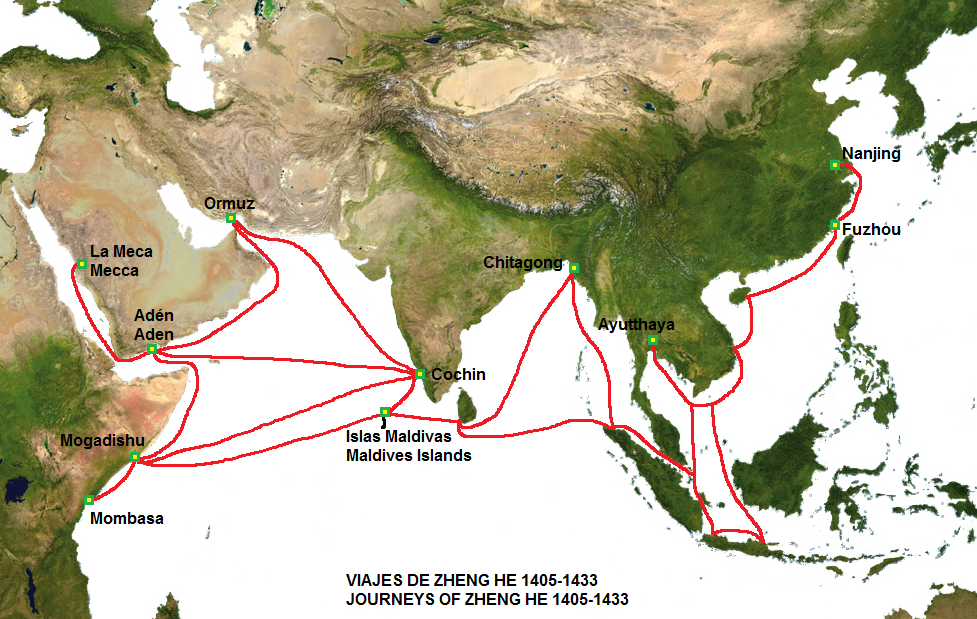 Again thank you for starting this thread, while it is one of my favourite subjects... Kind regards from your friend Paul. |
| | | | PaulRyckier
Censura
Posts : 4902
Join date : 2012-01-01
Location : Belgium
| | Subject: Re: Antique Maps & Explorers Fri 14 Jul 2017, 21:38 | |
| And Triceratops to add "our" Mercator from Rupelmonde and his 1569 worldmap, which seems to be a résumé of all the previous ones? https://en.wikipedia.org/wiki/Mercator_1569_world_mapAnd about Mercator: https://en.wikipedia.org/wiki/Gerardus_MercatorAnd even that...  ... From Wiki: The question of nationality[edit] 


Mercator's nationality is contentious. In 1868, in preparation for the 300th anniversary of the famous world map of 1569, the Belgian Jean Van Raemdonck published a biography of Mercator, the Flemish geographer, in which he presented a speculative Cremer family tree with ancestors in Rupelmonde.[11] In 1869, in Duisburg, Arthur Breusing published a small book on Mercator, the German geographer, in which he claimed that the family was from Jülich, Mercator was conceived there, and consequently his birth during the visit to Rupelmonde didn't invalidate his German nationality.[12] The debate continued in 1914 when Heinrich Averdunk attacked Van Raemdonck's 'fictions' and argued that the many occurrences of the name Kremer in Jülich in the sixteenth century supported Breusing's claim that the family was German.[13] Today, many Belgians and Germans still claim Mercator as their own, despite the lack of any evidence pertaining to the birthplace and background of his father, Hubert. Most modern scholars adopt a neutral position, hesitating to assign a nationality to Mercator, but many popular accounts simply plump for one nation or another without evidence.[14]
And of course in 1914 during the German occupation of Belgium: "The debate continued in 1914 when Heinrich Averdunk attacked Van Raemdonck's 'fictions' and argued that the many occurrences of the name Kremer in Jülich in the sixteenth century supported Breusing's claim that the family was German. "In wars, conflicts and occupations, history "can" be distorted in the advantage of the big "stick" of the moment... We have even a German name on the last house of the Torhoutse Steenweg in Bruges...from WWI...and the Belgians have forgotten to remove it in 1918 .... Kind regards, Paul. |
| | | | nordmann
Nobiles Barbariæ
Posts : 7223
Join date : 2011-12-25
| | Subject: Re: Antique Maps & Explorers Tue 08 Jan 2019, 09:58 | |
| An article in today's Guardian about Stanford's, the famous London map-makers and travel bookshop, features a beautiful 1870 map of the world showing the trade winds. I recommend you click on "enlarge" ...  |
| | | | Triceratops
Censura
Posts : 4377
Join date : 2012-01-05
| | Subject: Re: Antique Maps & Explorers Wed 09 Jan 2019, 14:30 | |
| |
| | | | Triceratops
Censura
Posts : 4377
Join date : 2012-01-05
| | Subject: Re: Antique Maps & Explorers Wed 09 Jan 2019, 14:56 | |
| Ptolemy's GeographyA Byzantine Greek world map according to Ptolemy's first (conic) projection. From Codex Vaticanus Urbinas Graecus 82, Constantinople c. 1300. Parchment 575 x 418 mm. Probably assembled by Maximus Planudes; later in possession of Palla Strozzi (1372-1462) then with Federico da Montefeltro, Duke of Urbino.  |
| | | | PaulRyckier
Censura
Posts : 4902
Join date : 2012-01-01
Location : Belgium
| | Subject: Re: Antique Maps & Explorers Wed 09 Jan 2019, 22:18 | |
| - Triceratops wrote:
- Ptolemy's Geography
A Byzantine Greek world map according to Ptolemy's first (conic) projection. From Codex Vaticanus Urbinas Graecus 82, Constantinople c. 1300. Parchment 575 x 418 mm. Probably assembled by Maximus Planudes; later in possession of Palla Strozzi (1372-1462) then with Federico da Montefeltro, Duke of Urbino.
Triceratops, thank you again for this map. Seeking for comments on this map, I didn't find any, but I found this cartotheek, perhaps interesting for you: http://www.wildernis.eu/chart-room/Kind regards from Paul. |
| | | | Vizzer
Censura
Posts : 1853
Join date : 2012-05-12
| | Subject: Re: Antique Maps & Explorers Sun 13 Jan 2019, 16:10 | |
| - nordmann wrote:
- a beautiful 1870 map of the world showing the trade winds.
Perhaps the most significant aspect on that map is the Arctic coastline. This was generally known in quite some detail by that time and had been quite accurately guessed at as early as the 16th century as evidenced by the maps of the Flemish cartographers Gerardus Mercator and Abraham Ortelius etc. Another Flemish cartographer Cornelis de Jode even produced a polar projection map as early as the 1590s:  By the 1870s the detail on the Arctic coastline had been cobbled together piecemeal following many separate expeditions mainly from land. It wasn’t until 1879, however, that the first complete navigation of the Northeast Passage was achieved. This was by Finnish explorer Nils A E Nordenskiöld who (140 years ago this month) was stuck on his ship Vega in the ice just north of the Bering Strait having spent the previous 7 months sailing along the northern coast of Russia from west to east. He and his crew must have been desperate to get out of the ice, along the last few miles of coastline, thru the Strait and into the Pacific Ocean to inform the world of their achievement. But they would have to wait until the spring thaw before they could do that. A rather unsung figure in the history of navigation, A E Nordenskiöld nevertheless has not 1 but 2 glaciers named after him, the first is on Spitsbergen in Svalbard and the other is on the west coast of Greenland. There is also a river in the Yukon named after him. His nephew Nils O G Nordenskjöld, also an explorer and not to be outdone, has a a third glacier named after him. This is on South Georgia in the South Atlantic. So that’s 3 glaciers in the world named after one family! Nordenskjöld also has a lake in Chile and several other geographical features in Antarctica named in his honour. This younger Nordenskjöld was a sort of Swedish equivalent of Ireland’s famous Ernest Shackleton. In 1903 O G Nordenskjöld, as leader of the Swedish Antarctic Expedition, had seen his ship crushed by ice and he and his men forced to take hurried and desperate measures overwintering on a bleak island before being rescued by the Argentinean navy. This was a pre-echo of what would happen 13 years later with Shackleton’s Trans-Antarctic Expedition in 1916 when he and his party would be rescued by the Chilean navy. The older A E Nordenskiöld, as well as being an explorer, was also a great collector of early maps especially those relating to the Arctic. And he donated his considerable collection to the University of Helsinki where it resides to this day. Here's an interesting article on cartography from a contemporary Finnish collector: The collector's story in his own words With regard to the other Arctic passage, the Northwest Passage, then it would be more that 25 years after Nordenskiöld sailed along the Northeast Passage before that was finally navigated. That was in 1905 and was undertaken by none other than Norway’s Roald Amundsen. Following the disaster which had befallen the British expedition under John Franklin in the 1840s, subsequent expeditions had proven that a Northwest Passage did indeed exist and was navigable. Amundsen, however, would be the first to successfully sail it. |
| | | | PaulRyckier
Censura
Posts : 4902
Join date : 2012-01-01
Location : Belgium
| | Subject: Re: Antique Maps & Explorers Sun 13 Jan 2019, 23:08 | |
| Thank you so much, Vizzer, for this map collection and the accompanied comments. I read it all from a to z and enjoyed it.
Kind regards from Paul. |
| | | | Vizzer
Censura
Posts : 1853
Join date : 2012-05-12
| | Subject: Re: Antique Maps & Explorers Sun 13 Nov 2022, 13:02 | |
| - PaulRyckier wrote:
- Triceratops wrote:
- The Kangnido Map of 1402. Originating in Korea, this map was probably used by the Chinese Admiral, Zheng He, during his voyages to the Western ( ie Indian ) Ocean in the 1420s:
Zheng He
Triceratops thank you so much for this splendid thread...explorations in which I am already interested since my childhood....I made several contributions about the subject on the old Beeb, among others as a reply to a contributor about these voyages and Gavin Menzies: "1421" It’s interesting to compare the Kangnido map to the Chinese Da Ming Hunyi Tu map from a few years earlier (c. 1389). 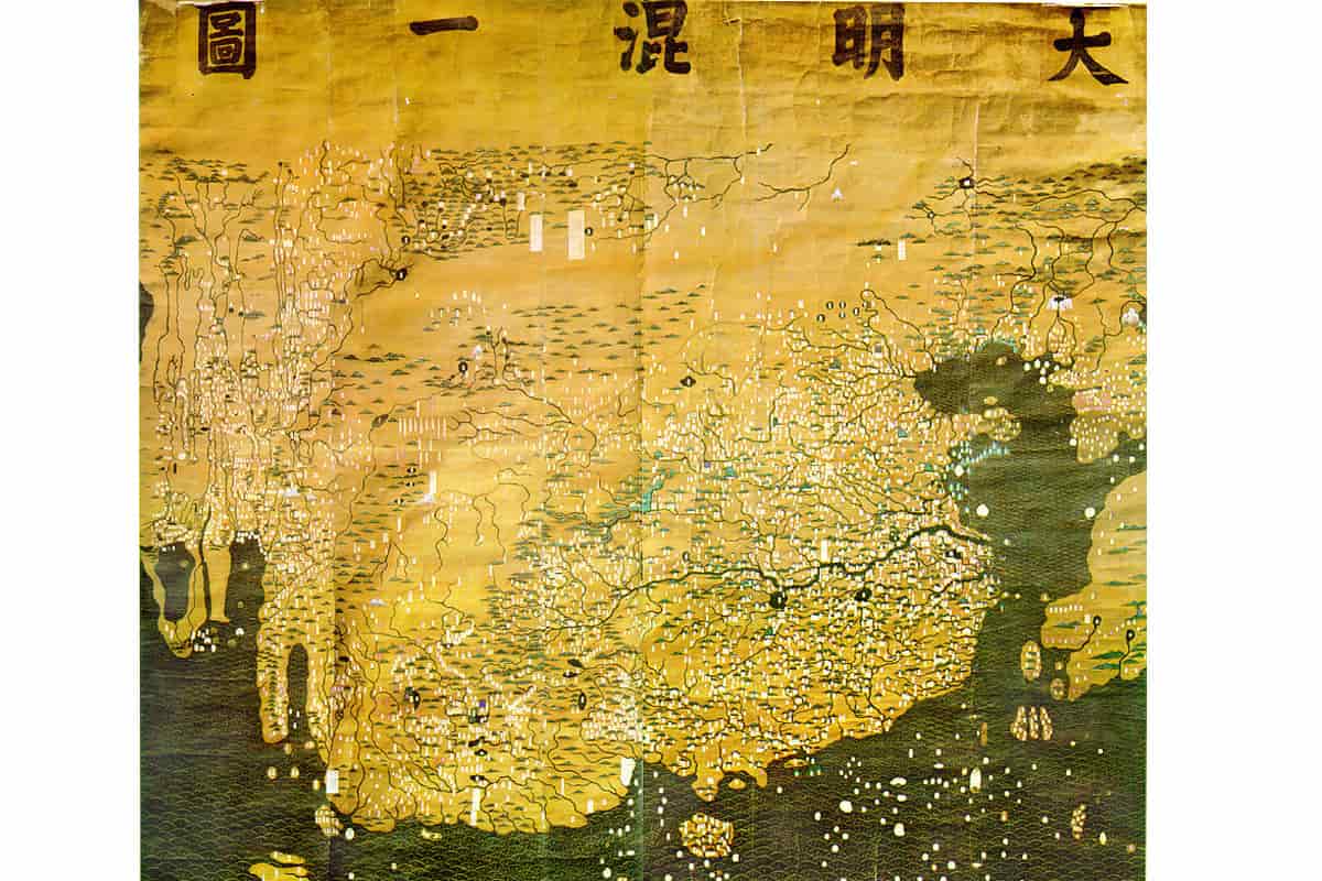 Near the bottom-left of the Da Ming Hunyi Tu map is a peninsula which looks like an elephant’s trunk (or whatever one’s imagination thinks that it might look like). That peninsula, however, is somehow missing on the Kangnido map. Further west (on both maps) are 2 other peninsulas which are generally believed to represent the Arabian peninsula and Africa. There’s a large lake in the middle of ‘Africa’ which presumably is Lake Victoria / Nyanza. What’s intriguing, though, is how the idea of the Arabian peninsula and Africa jutting out into the sea was much more prominent in the minds of the Kangnido mapmakers than was the prominence of India or indeed the Malay peninsula. This despite India and Malaya being geographically much closer to the Far East and presumably better known to Chinese and Korean cartographers. One suggestion is that information regarding the western reaches of the map came second-hand from Arab and Persian seafarers in Malacca and was thus reproduced by the Chinese and the Koreans without much question. What factors caused the Korean mapmakers to airbrush the ‘elephant’s trunk’ out of their map, however, remains something of a mystery. |
| | | | Sponsored content
| | Subject: Re: Antique Maps & Explorers | |
| |
| | | | |
Similar topics | |
|
| | Permissions in this forum: | You cannot reply to topics in this forum
| |
| |
| |