Posts : 3305 Join date : 2013-09-16 Location : North-West Midlands, England
Subject: Waterways Sun 30 Aug 2020, 12:53
Thinking of waterways, a former neighbour who had lived for some years in Colombia told me about the Casiquiare Canal or river which is a fast flowing body of water linking the Amazon and Orinoco river systems. He told me it was unusual in that it was a naturally occurring phenomenon and not a canal which had been excavated by humans. Wikipedia seems to back up his statements:-"The Casiquiare river (Spanish pronunciation: [kasiˈkjaɾe]) is a distributary of the upper Orinoco flowing southward into the Rio Negro, in Venezuela, South America. As such, it forms a unique natural canal between the Orinoco and Amazon river systems. It is the world's largest river of the kind that links two major river systems, a so-called bifurcation. "
Does anyone know of any other naturally occurring bifurcations? Wikipedia does say "the largest river of the kind".
nordmann Nobiles Barbariæ
Posts : 7223 Join date : 2011-12-25
Subject: Re: Waterways Sun 30 Aug 2020, 13:24
Bifurcation leading to a connection between two river systems is extremely common, though completely natural navigable examples are a rarity.
It occurs most often in flatter areas - the greater the gradient down which water travels the more likely it is to create a directional bias for the mass of its volume and therefore less prone to bifurcation. However when rivers encounter flatter land there is a greater tendency to split off into separate channels of least resistance, the reduction in flow allowing gradual accumulation of mass through several alternative routes instead of a biased accumulation of mass through one primary route. When one of these channels happens to eventually run into another such channel from another river system then this is a bifurcation of the type you found in South America.
Many of the canals in Belgium, Northern France and the Netherlands, although extensively dredged, walled and cut by humans, follow original bifurcatory routes. This makes sense as the canal is automatically therefore following a path that natural flow had determined was the optimum route through the terrain. All the humans have to do is to straighten them up a bit and deepen them, but can remain confident that the water levels and volumes can be maintained using the area's natural levels of saturation, determined by the actual rivers from which the channels originally diverted. Ensuring consistent volumes throughout a canal system, which includes consistent drainage as much as consistent supply, is much easier when the canal follows an existing route already established naturally, and linking two river systems exploiting existing natural bifurcation simply makes most sense.
The route of the Manchester Ship Canal for example, linking the Mersey and Irwell rivers, also follows what was a bifurcatory network of waterways that even as early as the 17th century had suggested themselves to Cromwellian engineers as good candidates for conversion to something that ships could navigate. I imagine that Britain abounds with such examples, especially in areas of comparatively equal elevation, for example through the broads or through large coastal plains which accommodate at least two main river systems.
PaulRyckier Censura
Posts : 4902 Join date : 2012-01-01 Location : Belgium
Subject: Re: Waterways Sun 30 Aug 2020, 15:49
LiR,
I read for the first time about it in "The Geographical Magazine" from the UK.
I read then in 1968 the Geographical Magazine to learn English. But I had to receive it in that time via my newspaper shop as they had to obtain it special for me from Britain. https://en.wikipedia.org/wiki/Geographical_(magazine)
And as I understood it from that issue the expedition was organized by "The geographical magazine"? But now I read that it was the National Geographical in the first range research wiki: https://en.wikipedia.org/wiki/Casiquiare_canal In 1968 the Casiquiare was navigated by an SRN6 hovercraft during a National Geographic expedition.[4] ??? I lost a lot of time by searching for that enigma, but stopped it...
And I found an image of one of the Geograpical isues:
Kind regards, Paul.
PaulRyckier Censura
Posts : 4902 Join date : 2012-01-01 Location : Belgium
Subject: Re: Waterways Sun 30 Aug 2020, 15:54
And nordmann I enjoyed very much your as always to the point (without any deviation) and well brought message about the subject. I learned from it.
Kind regards from Paul.
Priscilla Censura
Posts : 2769 Join date : 2012-01-16
Subject: Re: Waterways Sun 30 Aug 2020, 16:13
There does not seem seem to be development of a natural or ancient link but the meeting of canals at Hawkesbury Junction is a favourite of ours. The fall between locks when we last used it was about 6 inches hence my wondering about a natural waterway. It's on one of the oldest cuts with over 200 hundred years of on going activity - and a delightful place to visit - and also for the helm to swing a narrow boat from one canal to another. To get maximum joy of that, off load the entire crew on any pretext and enjoy it alone. It is possible that the muddle in the middle Rhine has also been a man assisted natural way. Someone else will know better. There may be one on the Loire lateral network also. That being a hairy place with large commercial trade the holiday helm doesn't get to think much about origins at the time.
PaulRyckier Censura
Posts : 4902 Join date : 2012-01-01 Location : Belgium
Subject: Re: Waterways Sun 30 Aug 2020, 21:42
A canal, in fact two short canals, which made the link between natural waterways to connect Bruges with Ghent. It was even the start of a war for the rivalry between Ghent and Bruges
First they made a connection between the "Zuidleie" the headwaters of the Reie from Bruges and the "Hoge Kale" the lower reaches of the Durme, near Beernem and St Joris-ten-Distel. Bruges wanted then to make a connection from the "Hoge Kale" to the "Leie" near Deinze and that was one of the reasons and the start of a five years war between Louis of Male and Ghent. https://en.wikipedia.org/wiki/Battle_of_Beverhoutsveld The city of Ghent had rebelled against their lord, count Louis II of Flanders, in 1379. The powerful guilds in Ghent did not take kindly to his rule, and wanted more privileges and less interference from the count. The nearby city of Bruges was a loyal supporter of the count and this only served to fan the flames of the rivalry between the two cities, both commercial powerhouses. The Gent-Oostende canal is one of the oldest shipping routes in Belgium. A natural watercourse between the towns of Bruges and Beernem was adapted for this shipping route. It was this piece of canal that caused the conflict between the Bruges and Ghent people. To force Ghent to surrender, the Count of Flanders had blockaded the access roads to the city. Philip van Artevelde, the leader of the Ghent rebels, was attempting to negotiate with the Count in Doornik, but these negotiations failed and the only option was to assault the town of Bruges to force access to the sea.
At the end Bruges and Ghent made no connection via the Leie but directly from the Durme to Ghent...
It is unbelievable but about the Canal Ghent-Bruges there seems not to exist a wiki in English or other sources on first sight about the history of it. https://nl.wikipedia.org/wiki/Kanaal_Gent-Brugge
Paul.
Last edited by PaulRyckier on Mon 09 Nov 2020, 15:26; edited 1 time in total
LadyinRetirement Censura
Posts : 3305 Join date : 2013-09-16 Location : North-West Midlands, England
Subject: Re: Waterways Fri 25 Sep 2020, 11:27
Belatedly, thank you for the information imparted about bifurcation, nordmann.
I'd been using material from this channel as unheard dictations for shorthand but found the content about the Colorado River and perhaps over-use of irrigation water therefrom leading to aridity in some parts of the American west interesting if disturbing. I'm sure I'd heard that something similar had led to the drying of the Aral Sea in the former USSR.
Vizzer Censura
Posts : 1816 Join date : 2012-05-12
Subject: Re: Waterways Mon 09 Nov 2020, 12:57
nordmann wrote:
The route of the Manchester Ship Canal for example, linking the Mersey and Irwell rivers, also follows what was a bifurcatory network of waterways that even as early as the 17th century had suggested themselves to Cromwellian engineers as good candidates for conversion to something that ships could navigate. I imagine that Britain abounds with such examples, especially in areas of comparatively equal elevation, for example through the broads or through large coastal plains which accommodate at least two main river systems.
Bifurcation is also a contributory factor leading to brackish water in some waterways. The River Hull is one such example.
The burgeoning wool trade of the 14th century saw Kingston upon Hull become one of the busiest ports in England. The rapid growth of the town coincided with a realization that the town’s location surrounded by saltmarsh made securing fresh water problematic and expensive. The lower reaches of the River Hull were brackish and much of the town’s water supply had to be ferried in boats across the Humber from Lincolnshire on the south bank where the clay and silty soil was more conducive to fresh water. This problem was seemingly resolved in 1376 when a royal commission declared in favour of digging a canal perpendicular to the River Hull and parallel to the Humber, westwards beyond the salty ground and into the wold country in order to bring fresh water into the town. The project was helped by the fact that king Edward’s chief exchequer was Michael de la Pole himself a Hull man. So far so good. Edward’s death, however, a few months later prompted the residents of the wold villages to mount a counter campaign in opposition to the canal in the belief that they would lose water to the town to their detriment. The villagers were supported in this by the town of Beverley which at that time was more populous than Hull and was distrustful of its rapidly growing neighbour - a municipal rivalry which sometimes persists to this day.
The new king Richard II was only 9 years of age when he succeeded to the throne and de la Pole suddenly found himself playing piggy-in-the-middle between the young king’s uncles Thomas of Woodstock and John of Gaunt each of whom vied with the other for control of the regency. Any hint of partisanship on the part of de la Pole with regard to, say, the canal dispute would merely have added ammunition to Woodstock and Gaunt, both of whom were also jealous of his friendship with Richard and enviously perceived him as being a de facto regent. Consequently, the canal project was put on hold.
Fiscal scrupulousness by de la Pole, however, did not equate to fiscal probity by the regency as a whole and an ill-advised and costly war in France resulted in the introduction of a poll tax to pay for it. This is turn triggered the Peasant’s Revolt resulting in the deaths of the Lord Chancellor and also the Lord High Treasurer among others. It also accelerated Richard’s coming of age and saw him appoint de la Pole as Chancellor. It seemed that the Revolt had actually boosted his career and things seemed to be on the up for Michael de la Pole. Yet the war in France (prosecuted by Gaunt) was ongoing and a parliament (dominated by Woodstock) was convened in 1486 with a view to raising revenue for it. This parliament, however, had de la Pole impeached and removed from office before a penny was raised and a stunned de la Pole went into exile in France. The fall of de la Pole was understandably a shock for Richard too and also marked the beginning of the end for his reign. Richard tried to regain the initiative by sending his other favourite Robert de Vere against his uncles militarily. De Vere, however, was defeated in battle and he followed de le Pole into exile.
(Richard II's favourite Robert de Vere going into exile following defeat at the battle of Radcot Bridge in 1387)
A rapprochement between Woodstock and Gaunt now saw the adult king more in hoc to his uncles than he ever had been as a child. Meanwhile in Yorkshire the opponents of the canal were cock-a-hoop that de Vere and de la Pole had gone and took steps to rub the inhabitants of Hull’s noses in it by digging their own irrigation channels and dykes against the flow of that which had been proposed for the canal. This state of affairs persisted for ten years until in a final throw of the dice, following Woodstock’s death in 1397 (who is believed to have been murdered on Richard’s orders) Richard swiftly took the opportunity to exile Henry Bolingbroke who had lead the forces which had defeated de Vere. It finally seemed that Richard was now king in deed as well as in name. And Gaunt’s death in 1499 should have sealed the deal. Yet Richard overreached himself by confiscating all of Gaunt’s lands which would have gone to his son, the exiled Bolingbroke. This high handed action alienated many of the other nobles and also a good deal of the commonalty too and Henry decided to return that same year to challenge Richard directly.
Landing at Ravenspur the first place his force encountered was Kingston upon Hull. Things didn’t bode well, however, when the mayor ordered the drawbridge raised and barred his entry declaring the town's loyalty to Richard. It looked as though Bolingbroke would fall at the first hurdle. Undeterred, however, he by-passed Hull and moved on to Doncaster where he received a more favourable welcome. In fact virtually the whole country (including the likes of Thomas Knolles and Richard Whittington in London) either declared for Henry or else passively stood by, which smoothed his path to the throne. The exception of Hull begs the question as to why he chose to land at Ravenspur in the first place.
Following his accession, however, Bolingbroke was not vindictive regarding the snub but rather was magnanimous in victory. So much so that he went on to patronize and prefer Hull to an almost embarrassing degree. The embarrassment must surely have been on the part of the mayor, however, for having opposed him. Within 18 months of Henry's accession he had not only renewed the town’s royal charters but had also set up another commission to look into the water supply which recommended the cutting of a canal deeper, wider and longer even than that which had been proposed in 1376. And this time the canal would be completed and was fully operational at the time of Henry’s death in 1413.
Today the canal has long since been built over, its original purpose superseded by subsequent canals and drains dug in the 17th and 18th centuries. Its memory is held only in the name of the suburban road, the Spring Bank, which follows its course. In a final twist, the adjacent Spring Bank Cemetery is the subject of Philip Larkin’s rather bleak poem Toads Revisited which ends:
When the lights come on at four At the end of another year? Give me your arm, old toad; Help me down Cemetery Road.
It’s unknown exactly who or what Larkin meant by ‘old toad’ here. Coincidently there is a story of Bolingbroke being referred to as a toad whereby a soothsayer is reported to have warned Richard II that ‘a toad should destroy him’. The Prose Brut relates:
And ther was, yn Kyng Richardys courte, a worshipful clerke þat was an Astronomier, which knewe & vndyrstode be his counnyng þat King Richarde shulde be slayne & destroyed be a Toode. And vpon a tyme, he warnyd þe Kyng therof & bad hym ‘be ware of Todys; for a Toode shulde destroye hym;’ and than þe Kyng thouht & mervayled in his mynde, how þat shulde be. And vpon a tyme he ordeyned & made a ryal feest in Cristmasse, & comaundyd al his lordys to come thedyr. And they cam thedyr, euery lorde in þe gayest desgysynge þat they coud devyse. And among hem alle, Sir Herry, Erle of Derby, cam in a Gounne broyderyd al abowte with Toodys. & whan Kyng Richard syhe yt, he remembryd þe propheci of Toodys þat his clerke tolde hym, þat he shulde be destroyed by. And euer aftyr he had his Herry, Erle of Derby, yn Ielwsy & mystruste, supposyng þat it shulde be he þat shulde destroy hym; & fayne þe Kyng woolde an had hym destroyed; but at þe last he exiled hym for x yer.
Whatever the relevance of the prophesy, misfortune for Richard, however, would mean fortune for his loyal town of Hull and its water supply.
PaulRyckier Censura
Posts : 4902 Join date : 2012-01-01 Location : Belgium
Subject: Re: Waterways Fri 13 Nov 2020, 19:28
I enjoyed your story about Kingston upon Hull, Vizzer. I had nevertheless to look up for Richard II (as I am not such an insider in British history) and yes now I understood it all.
As the picture from the site don't work I found it somewhere else
(Taken from Eric de Mare's "Canals of England)
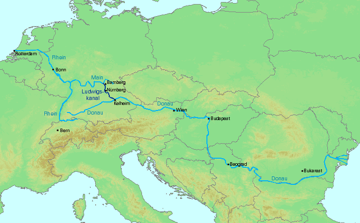
What I first didn't understand from GG, when he said: "lockless" I learned now from the wiki he provided. Unbelievable...a complete horizontal waterlevel possible from Newcastle till Liverpool, Southampton, Liverpool and London...on 300 feet above sealevel? that's now a breathtaking project... And yes one has to think at a "green" future... (Liquified Hydrogen fuelled barges?)...but the question will perhaps be is it economical profitable...?
From the wiki: "The containertraffic declined from 3,986 to 2,539TEUs. Of these 85% were in the direction of Danube. Meanwhile,tourismalong the canal is economically important. This has contributed to the extensive creation of habitats to compensate for the canal."
"Analysis by theEuropean Court of Auditorspublished in 2020[6], examined the economic case and stated that: "The Seine-Scheldt inland waterway link was approved on the basis that traffic levels on the Canal Seine Nord Europe by 2060 would be four times as high as the reference situation in 2030 without the Canal. To achieve this a significant increase in freight volumes on the axis across France and Europe is necessary. However, the statistics from the last decade do not suggest that this will occur. In addition, two specific conditions are necessary, none of which seem particularly realistic in the light of industrial trends over time: — a fourfold increase – from 2.3 million tonnes per year to 8.1 million tonnes per year – in traditional flows of construction materials moved by inland waterways using the Canal Seine Nord Europe over the 30 years following entry into service. For such a significant modal shift to come about, various accompanying conditions (e.g. tolling) would need to be put in place. — a massive diversion of containerised road traffic to waterways, resulting in 36 % of freight on the entire traffic axis being shifted onto the waterway. This would require the current proportion of freight carried by waterway on that axis to be multiplied by 38, or the share of container traffic volumes to be three times as high as it currently is for the entire Rhine river."
Kind regards, Paul.
LadyinRetirement Censura
Posts : 3305 Join date : 2013-09-16 Location : North-West Midlands, England
Subject: Re: Waterways Sun 05 Sep 2021, 00:06
The tidal bore on the River Severn is well known but I hadn't realised until stumbling upon something recently that the Mersey has a tidal bore - though it's less spectacular than the Severn bore and doesn't always show. There seem to be more tidal bores than I realised in the UK even if they aren't lare ones that surfers ride - though of course I've known that estuaries were tidal. The Trent aegir can be noticeable. Of course though I live near a tributary of the Trent I'm much too far inland/upstream for the aegir to feature near here.