|
| | Google Street View and World War Two |  |
| | Author | Message |
|---|
nordmann
Nobiles Barbariæ

Posts : 7223
Join date : 2011-12-25
 | | Subject: Google Street View and World War Two Tue 20 May 2014, 13:30 | |
| From today's Guardian newspaper an interesting montage of "then and now" images combining contemporary Google Street Views with photographs from the Second World War in London, Berlin, Hiroshima and Paris, amongst others. Second world war in Google Street View Balham - where 70 people died on October 14th 1940 when their air raid shelter was flooded from a bombed water main. |
| | | | Meles meles
Censura

Posts : 5122
Join date : 2011-12-30
Location : Pyrénées-Orientales, France
| | Subject: Re: Google Street View and World War Two Tue 20 May 2014, 14:12 | |
| Thanks for those Nord. With modern picture editing software and the increasing availability of photos on-line, these sort of pictures, marrying recent views with old, are becoming very popular. I wonder how soon it will be before someone starts doing similar things with old, pre-photography engravings and paintings? (Actually I'm pretty sure someone already has).
But just a thought regarding Google Earth images ... when they are upgraded, are the old ones archived for posterity, or are they lost? They would be an invaluable source for future historians. And they already have quite a souvenir function. The last time I looked Google Earth's view of my parents' house clearly showed Dad's red Fiesta parked in the drive and his beloved greenhouse at the bottom of the garden. But he died in 2005 and I know both of these no longer exist. And if it hasn't already been updated I'm sure the relevant image will be changed very soon. |
| | | | nordmann
Nobiles Barbariæ
Posts : 7223
Join date : 2011-12-25
| | Subject: Re: Google Street View and World War Two Tue 20 May 2014, 14:47 | |
| I'm a sucker for these "then and now" montages, especially when they're done well. This site Sepia Town was an attempt to build a comprehensive database marrying old images with contemporary Google Street Views. It seems to have run out of steam since its inception in 2010 unfortunately, though it still has some quite successful comparisons. I am sure with the older Google earth images etc that they are "saved" in some manner in some nebulous realm of the interwebby thing when replaced in the application, but you can always save the image yourself locally too I suppose if it's a scene you really would like to keep. |
| | | | Meles meles
Censura
Posts : 5122
Join date : 2011-12-30
Location : Pyrénées-Orientales, France
| | Subject: Re: Google Street View and World War Two Wed 21 May 2014, 14:22 | |
| Someone recently did some really good ones of the town where I was brought up. Apparently they had terrible trouble getting exactly the same vantage point to match the old photos. All the old nineteenth century ones, which were taken by the same local photographer, seemed to all have been taken from about ten feet above both the old and new street level.
After a bit of discussion on a local online forum it emerged that nearly all the original photos were taken from outside pubs, and that the photographer was from local brewing family. And so it seems highly likely that he used to cadge a lift on the brewery cart and take his photos from the high-up position it offered whilst it was legitimately stopped in the middle of the street delivering beer barrels to the town's pubs.
To get the same shots the modern photographer had to use a stepladder, and not only have the support and assistance of numerous local shops and businesses, but also that of the council and the police, since what were once just bustling parochial streets are now major transport routes. |
| | | | Vizzer
Censura

Posts : 1854
Join date : 2012-05-12
| | Subject: Re: Google Street View and World War Two Fri 23 May 2014, 23:29 | |
| - Meles meles wrote:
- I wonder how soon it will be before someone starts doing similar things with old, pre-photography engravings and paintings? (Actually I'm pretty sure someone already has).
An obvious one this - Flatford Mill (2007) combined with The Hay Wain (1821): 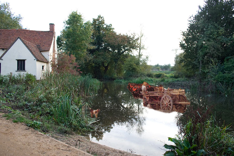
Last edited by Vizzer on Thu 28 Dec 2023, 21:26; edited 1 time in total (Reason for editing : to fix broken link) |
| | | | Meles meles
Censura
Posts : 5122
Join date : 2011-12-30
Location : Pyrénées-Orientales, France
| | Subject: Re: Google Street View and World War Two Thu 05 Jun 2014, 15:51 | |
| Not quite the same thing but .... in the little port of Collioure, just down the road from me, there's a Fauvism Art Trail. At the beginning of the 20th century Collioure was suffering from the collapse of its two principal businesses: fishing and wine, so it was a cheap Mediterranean holiday destination for those who couldn't afford the Côte d'Azure. Henri Matisse first came to Collioure because he was looking to escape the Parisian summer and he needed cheap lodgings for his wife, two little boys and his older daughter (by a former mistress). He was joined there by André Derain. Both artists were impressed by the quality of the light and the colour ... this short stretch of coast is unique in being the only east-facing coastline in France. They were followed by other artists and Collioure soon became the centre of the so-called fauvism movement. Today the formerly impoverished fishing village is a chic resort, its ancient winding streets full of artists' studios and galleries, its medieval harbour full of luxury yachts, and its castle and harbour walls crammed with amateur painters desparately trying to create their own masterpieces. Around the town, there are now over twenty reproductions of the works of Matisse, Derain and others, displayed where the artists perched their easels, along with mounted metal picture frames through which you can also 'frame' the exact scene that these painters saw:   Matisse, Vue de Collioure - L'eglise, 1905.  Derain, Le Phare de Collioure, 1905. ..... and of course one can also view many of the original paintings in the local Musées d'Art Moderne, either in Collioure itself, or at Cérèt about 30 mins inland. |
| | | | Vizzer
Censura
Posts : 1854
Join date : 2012-05-12
| | Subject: Re: Google Street View and World War Two Thu 28 Dec 2023, 21:32 | |
| This one compares the Lord Mayor of London's River Procession by Canaletto from 1747:  with Queen Elizabeth II's Diamond Jubilee River Pageant in 2012. |
| | | | Meles meles
Censura
Posts : 5122
Join date : 2011-12-30
Location : Pyrénées-Orientales, France
| | Subject: Re: Google Street View and World War Two Mon 08 Jan 2024, 13:18 | |
| Canaletto's paintings are absolutely marvellous for their precision, accuracy and architectural detail. Accordingly I'm intrigued by the minaret-like spire on the sky-line towards the east, 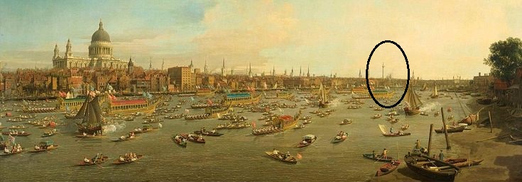 ... especially when looking closer, such as here from a slightly higher resolution image but of the same painting, 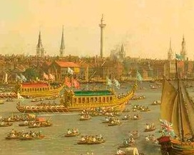 Is that the Monument to the Great Fire of 1666? If so it seems unusually tall and wide at the top. Or is it that I'm just used to seeing modern images of central London crowded in by truely gigantic towers: the Shard, the Gherkin etc. But if it isn't the Monument then whatever is it? |
| | | | Vizzer
Censura
Posts : 1854
Join date : 2012-05-12
| | Subject: Re: Google Street View and World War Two Tue 09 Jan 2024, 19:18 | |
| I think that it can only be the Monument, Meles, but like you I was unaware of just how imposingly tall the structure was when built. It’s certainly in the right place and is the right shape. Quite amazing to think that it was already 70 years old at the time when Canaletto was painting. Here are some other views of London superimposed onto paintings by Canaletto and other artists: Then and Now: London in PaintingsThe one of the Strand from 1822 is particularly good. |
| | | | Meles meles
Censura
Posts : 5122
Join date : 2011-12-30
Location : Pyrénées-Orientales, France
| | Subject: Re: Google Street View and World War Two Thu 11 Jan 2024, 15:21 | |
| I've only ever seen the Great Fire Monument looking up from street level. So yes it is tall, but it's now rather over-shadowed by other, much-taller, buildings. Paintings by Canaletto - as well as those by his pupil and nephew Bernardo Bellotto (who often 'signed' with his uncle's name just to confuse matters) - are so finely-detained and precise that they have been used to physically reconstruct whole cityscapes. Bellotto in particular completed 26 paintings of Warsaw in the years 1770–80 to embellish the so-called Panorama Room of the Royal Castle in Warsaw. These works were later relocated to Russia but were restored to the Polish Government in 1921 (the Treaty of Riga, I think) and then somehow manged to survive WW2, when so much Polish heritage was destroyed or looted by Germany. In particular the well-preserved, mostly baroque-style centre of Warsaw, having already been damaged by bombing and shelling prior to the city's capitulation in 1939, was then nearly-completely destroyed following the failed uprising in 1944. About 80–90% of of Warsaw's historic buildings were razed by dynamite including, deliberately, the vast majority of museums, art galleries, theaters, churches, castles, palaces and other buildings of significance to Polish heritage, history and culture. After the war the Polish government rebuilt much of the city in a typically communist style, but it was decided that the old city centre should be restored exactly as it had been before the war, when it had been a complete and beautifully preservered 18th-century urban centre. In this the restorers, in the absence of any surviving architectural blueprints, mostly used the detailed paintings of Bellotto. Today the buildings of the old town have the appearance of a preserved baroque city, although in fact nearly all of them were completely rebuilt in the 1950s. It seems that the general idea was to hand down to future generations at least the exact appearence of these monuments even if they were not always completely authentic, because the buildings were still alive in human memory and accessible through historical sources (such as Bellotto's paintings). To its detractors this approach carried the risk of ending up with a sort of token-toy-town or theme park. However in their stated aims, the restorers determined not just to create a theatrical likeness, but to try to ensure that the rebuilding met historic criteria and was completely credible. I have visited a couple of times and the uniformity of the restoration certainly makes it feel like an authentically preserved, rather than completely rebuilt baroque city. I can't match the cleverness of your then-and-now composite images of London, but these pictures do clearly show Warsaw ... as it once was, then during the war, and now. The view of Market Square with the Church of the Blessed Sacrament, painted by Bernardo Bellotto in 1778, 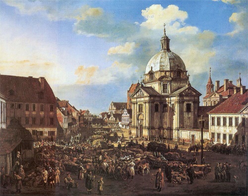 ... then the same place in about 1945, and as it is now having been rebuilt using Bellotto's painting. 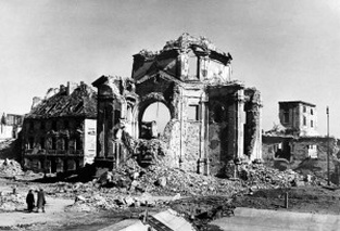 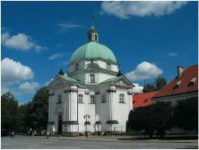 And then there's these three of Miodowa Street in Warsaw ... as painted by Bellotto in 1777; then in about 1945, and as it is now, having not just been restored but completely rebuilt according to Bellotto's original paintings. 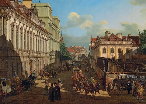 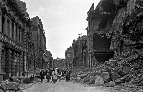 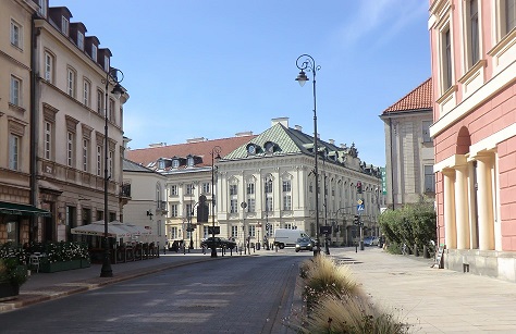 I think Bellotto's paintings of Dresden were similarly used during the post-war reconstruction of that devastated city. |
| | | | Sponsored content
| | Subject: Re: Google Street View and World War Two | |
| |
| | | | | | Google Street View and World War Two | |
|
Similar topics | |
|
| | Permissions in this forum: | You cannot reply to topics in this forum
| |
| |
| |
